
 Description
The KS700 metal detector ground radar locates from 0–40 m in the solid rock body. We have located tunnels from World War II up to 60 m in limestone, but you have to consider that these tunnels are approx. 5m wide and approx. 7 m high.
On the website, you can see a reference where we also used the device to locate smaller cavities from the 18th century, where crawl spaces were created for coal mining. These passages are 26.3m deep in the ground and were very well located with ground-penetrating radar.
The device can also be used for metal detection; in southern countries, it is very often used for this search task.
It is predestined for searching for cavities such as cellars, bunkers, tunnels, metal, etc., but also for searching for sewers, lines (electricity, water), old pits, and much more. The radar records the measurement data, and this data can be seen live on the tablet PC during the measurement as it is immediately displayed in a 2D graphic.
Therefore, we do not need different antennas
A user manual on CD is always included with the delivery of the ground-penetrating radar.
The complete measurement process with software and
device settings is explained and shown in these operating instructions.
Since our customers are represented worldwide, we have shot a video film that contains the following:
1. Setting up the ground radar
2. Switching on the ground radar
3. Setting the software
4. Complete the measurement process
5. Evaluation of the measurement diagram
6. Saving the measurement data (measurement image)
7. Switching off the ground radar
When the 2D software has started, you can see it in English. You can switch the software between English, German, and Turkish. Since English is the world language and we have several customers in Turkey, we decided to use German-English-Turkish software.
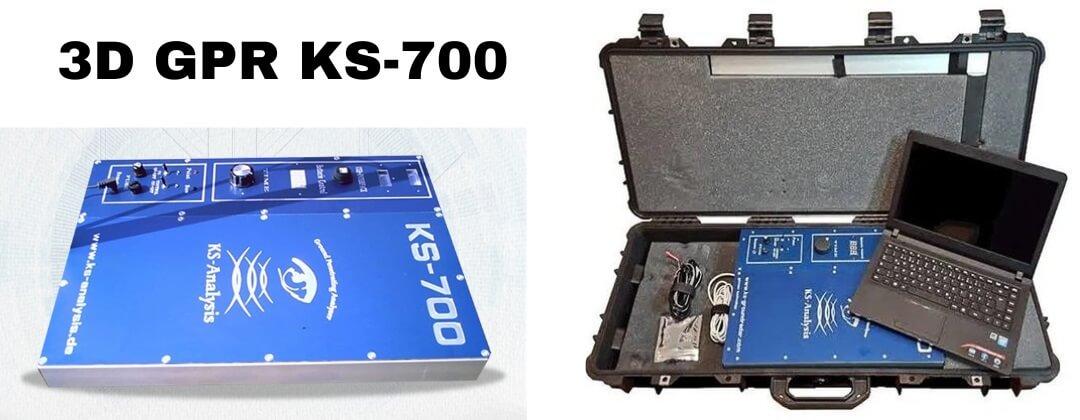
Features
- Electronic control unit
- 2D visualization software (the user can purchase 3D from Golden Surfer, Voxler can be used immediately with the device)
- equipment case
- USB cable
- battery connection cable
- 1 antenna (integrated into the device)
Most manufacturers offer different frequency ranges and therefore different antennas. The lower the frequency, the deeper you get, but the worse the resolution. Resolution means; locating a small object is not possible at low frequency, but better depth performance is achieved.
Therefore, some manufacturers of pulse radars offer different antennas in different frequency ranges. A compromise solution must be found to eliminate the existing geophysical contradiction as much as possible; what we have done with our device, by specializing in FMCW radar, we have chosen an operating frequency that, depending on the ground conditions, on the one hand, has good penetration and an acceptable resolution.
Software and measurement images Ground radar
The software implements the immediate display of the measurement image.
The display of the measurement profile is two-dimensional and enables the user to implement the measurement profile quickly.
Views on this can be found in our references.
2D MEASUREMENT PICTURES:
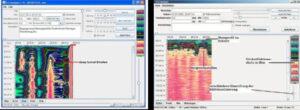
2D software is included. With the “Import-Export” function, the data can be transported in 3D software (3D Data Visualization Solution); eg in “Voxler” by Golden Surfer (not included).
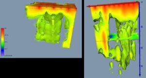
3D MEASUREMENT PICTURES:

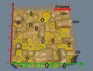
3D scanner gold detector KS-700 Metal Detector Ground Radar:
Refinement of previous radiometric and geophysical surveys
2D & 3D SAMPLING WITH KS-700
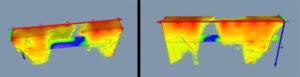
| Tunnel, visualization with 4m measuring point distance | Tunnel, visualization with 2m measuring point distance (right) |
MEASUREMENT OF AN UNDERGROUND WATERCOURSE AT A DEPTH OF APPROX. 8M
Specifications
| Radar type: | FMCW radar (Frequency Modulated Continuous Wave Radar) |
| Dimensions: | Length: 445 mm Width: 334 mm Height: 120 mm (without carrying handle) |
| Weight: | 5.1kg |
| Operating voltage: | 12 volt / ≥10 Ah battery |
| Channel: | Timed (1-15 seconds) |
| Sampling time: | 20ns-100ns |
| real-time sampling: | 1.25kHz – 50MHz |
| Max Sample: | 1GHz |
| Bandwidth: | A/D converter DC-60 MHz |
| data processing about | About FFT (Fast Fourier Transform) |
| FFT resolution: | 2048 lines |
| Achievable depth performance (in limestone) | 30interface |
| Interface: | USB |
| Software: | -Spectrum analyzer -2D visualization: Stone Age (English-German-Turkish) -3D visualization: Golden Surfer Voxler (English) |
| Delivery dimension/packaging: | 660 x 450 x 180mm (16kg) |